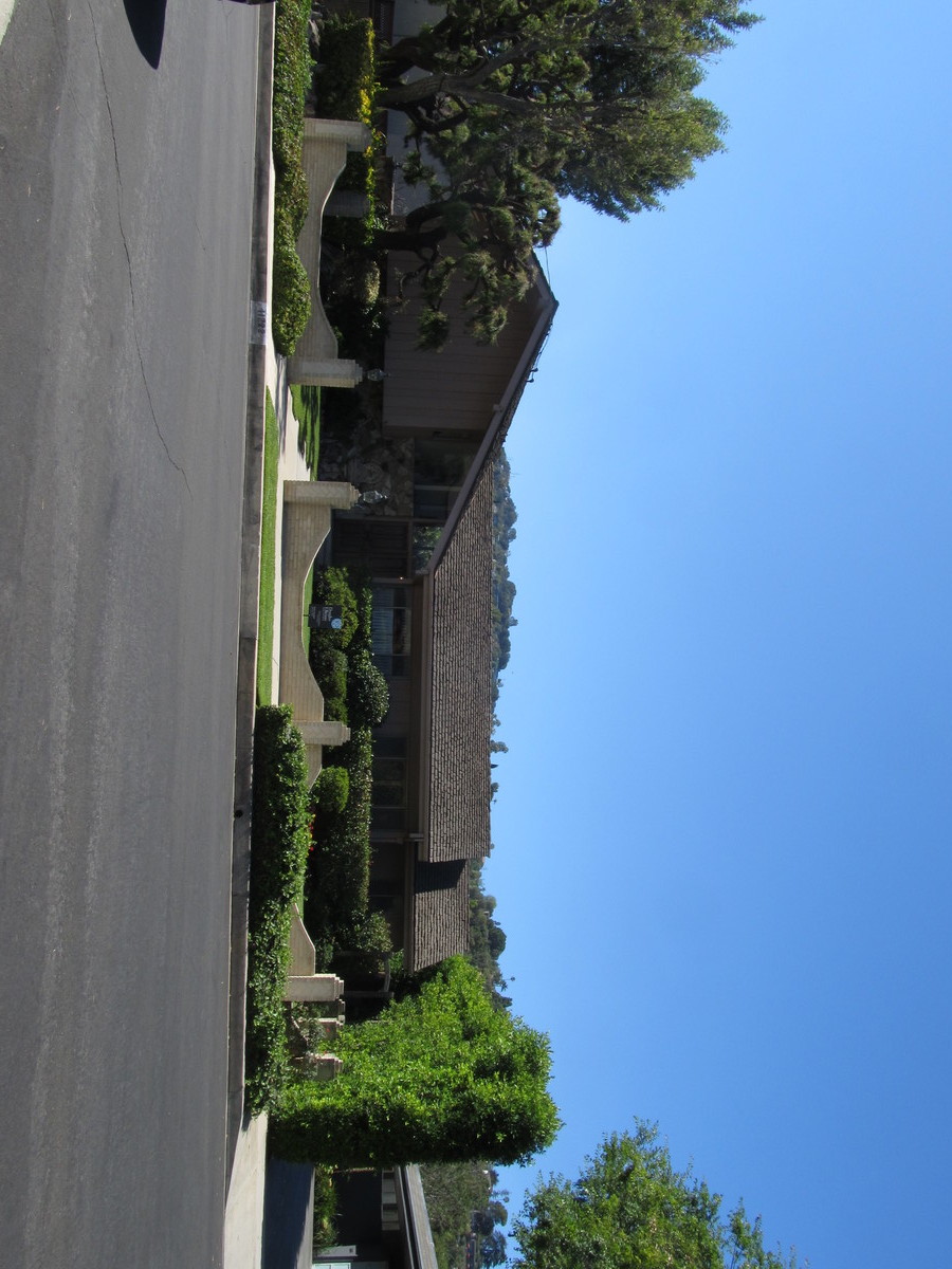
Stan’s Obligatory Blog

Page 12 of 93« First...«1011121314»203040...Last »

6/17/2018

The Presidential Twitter Library

Filed under: — stan @ 12:36 pm

Last Friday, I went out to West Hollywood to see the Daily Show’s Donald J. Trump Presidential Twitter Library, and I thought it was funny enough that it was our destination for the Sunday bike ride today.

The route was nearly identical to the route we took when we went to see the places that are “Instagrammed to death.” When we got there, there was already a line of people waiting to go in, so I guess word gets around. After that, we went for bagels at Noah’s in Larchmont, and then home by way of downtown L.A. All told, it was about 46 miles.

6/3/2018

Rubel’s Castle

Filed under: — stan @ 1:09 pm

Today’s bike club ride was another visit to Glendora to peek in on Rubel’s Castle. As it turned out, there was a group there about to take a tour given by the Glendora Historical Society, so we got to talk to them for a bit about the castle. So that was entertaining. Then we rode back down the hill for snacks at Classic Coffee before heading home.

39 miles.

Route map and elevation profile

5/27/2018

Maywood Again

Filed under: — stan @ 1:32 pm

It’s been a few months since we visited the giant shiny new pot shop in Maywood, and I’ve gotten some requests to go see that again. So that’s what we did today.

On the way into downtown, I stopped to take a few pictures of the warehouse-turned-gallery where the “Beyond the Streets” art show is being held. I’ve heard good things about it.

When we got to Maywood, the security guards at the pot shop remembered us from when we’d visited back in January. I guess they don’t get a lot of bike clubs visiting.

Heading back into downtown, we went out 7th St, and then up Bonnie Brae to Echo Park. And when we got there, we found out that Chango Coffee was no more. So we went a few blocks up the street to another hipster coffee shop and bakery. It was pretty good, but we really did like Chango.

46 miles.

Route map and elevation profile

5/20/2018

The ride to Whittier – Now with more teapot!

Filed under: — stan @ 1:23 pm

Today’s bike club ride was our regular route to Whittier, but this time with a short side trip to see a giant suspended teapot fountain outside an Asian shopping center in Temple City. When we started out, it was kind of misting and damp, but thankfully, that stopped once we got a few miles away from the mountains. We also discovered two new topiaries in front of a preschool in Temple City. And finally, we did the photo-op with Jen at Dork St in Pico Rivera. So all around, it was a fun little ride.

46 miles.

Route map and elevation profile

4/22/2018

Ciclavia Foothills Edition

Filed under: — stan @ 3:26 pm

Today’s bike club ride was the Ciclavia “Heart of the Foothills”. This was the first time that there was an official Ciclavia event inland. The route went from San Dimas to Claremont. When we ride to Claremont, it’s about a 58 mile round trip, which is a bit beyond our normal 40-45 for a Sunday ride. So the plan for today was to start by taking Metro to the end of the line in Azusa. From there, we rode to San Dimas, where we picked up the Ciclavia route. We rode the route out to Claremont and back. We didn’t stop in Claremont, since we wanted to get back before it got too crowded.

Back in San Dimas, we stopped for snacks at the Bagelry. Then we rode back to Pasadena. This made a total of 44 miles riding. When we first got off the train in Azusa, I forgot to turn on my GPS thingy, so it missed the first few miles. And it also didn’t count the initial two miles from the park where we start to the Metro station at Allen.

44 miles.

Route map and elevation profile

4/15/2018

Agents of S.H.I.E.L.D.

Filed under: — stan @ 2:14 pm

Yesterday, I was at the Aon building stair climb. While we were there, there was a crew setting up for shooting a scene for Marvel’s “Agents of S.H.I.E.L.D.” on Wilshire Blvd. They had lots of fake rocks and fake broken chunks of pavement, as well as a couple of fire cars, like the ones we saw in Griffith Park once that turned out to be for an episode of “Grey’s Anatomy”. The setup crew said they were going to be working all day to set the scene, and the actual filming would be done of Sunday morning, so that was our sightseeing destination for today.

We got an early start today, so we made it downtown in time to see the 8:46 Metrolink train to Lancaster go by. If we see that train, that means we made good time getting downtown.

When we got down to Wilshire, it was pretty obvious that this shoot was a Big Deal. There were a lot more prop cars, and hordes of extras in business suits with dirt smeared on their faces milling about. We even saw Chloe Bennet as Daisy Johnson there. Apparently, her super power is the ability to create earthquakes, which Jen and I thought was pretty funny, since that meant her character had the power to make us have to go into work.

After gawking at the shoot for a few minutes, we continued on our way. We made a loop out and back through Hancock Park. Then up Benton Way through Silver Lake and then to the L.A. River bike path. We stopped for snacks at Spoke. Then we headed home by way of the Arroyo Seco bike path.

41 miles.

Route map and elevation profile

4/8/2018

Bruce Lee

Filed under: — stan @ 2:09 pm

Today’s bike club ride was a trip to Chinatown in Los Angeles to see the bronze statue of Bruce Lee there.

We rode out across Eagle Rock and Glendale, and then down the L.A. River bike path. Then through Elysian Park to get to Chango Coffee in Echo Park. I’d remembered this time to check the Dodgers schedule to be sure there was not a game today, since that park gets pretty crowded on game days. We had snacks at Chango before taking Bonnie Brae St down to 7th St. This was novel, since we ride Bonnie Brae fairly often, but this was the first time we ever did it in this direction. It looked like a whole new street. We noticed The Bonnie Brae House for the first time today. We were wondering what was special about it.

Just before we got to 7th St, we passed 666 Bonnie Brae. The police and fire department were there in force today, for reasons that were not entirely clear. Then we turned on 7th and rode back in to downtown L.A. Then up Figueroa St to Chinatown. There, we went to see the Peephole Cinema, and then across Hill St to the Bruce Lee statue.

The route home was back up Huntington Drive, which is another route we do frequently, but not in that direction.

40 miles.

Route map and elevation profile

4/1/2018

Some Random Hollywood Sightseeing

Filed under: — stan @ 2:50 pm

This week I was a bit short on inspiration of things to go see, so we took a trip to Hollywood to see just a small random selection of items that we hadn’t gone to see before. Also, I’d been sick the previous week, so I wanted to do something a little on the easy side. And according to my logs, we hadn’t ridden out that direction in a while. The two bits of sightseeing on the route were RuPaul’s star on the Hollywood Walk of Fame, and the mural of silent movie stars underneath the Hollywood Freeway on Argyle Ave.

We rode through downtown Los Angeles, and then up through Hancock Park to get to Hollywood. When we got there, we found RuPaul’s star on Hollywood Boulevard. It was right in front of a storefront that was completely dedicated to advertising RuPaul’s Drag Con. Seemed appropriate. Then we headed across Hollywood on Selma Ave. We had to carefully pick our way through the Hollywood Farmer’s Market. Then we found the mural under the freeway, It’s right across from Castle Argyle. Both of those made brief appearances in “La La Land“.

We stopped for snacks at Spoke. And then headed up Figueroa St to go home. In South Pasadena, I bailed out and took Metro back, just because I was still getting over being sick last week.

38 miles, including the ride home from the Metro station.

Route map and elevation profile

3/25/2018

Sea Monsters

Filed under: — stan @ 5:29 pm

This past week, I saw an article on KCET about unusual and interesting parks in the L.A. area. In particular, I saw the pictures of the sea monsters at Whittier Narrows. These look a lot like the ones at Vincent Lugo Park in San Gabriel, which we’ve been to see before. So I thought it might be interesting to go and visit both sets of sea monsters on our Sunday ride this week.

We started off heading down to San Gabriel by way of Alhambra. The sea-monster playground is all the way at the back of Vincent Lugo Park there. We climbed a bit on the sculptures and took some photos there. Then we headed east to get to Whittier Narrows. We’ve been by there hundreds of times, but never actually gone into the park. I’d looked at the aerial views in Google maps to see where a couple of the sea monsters were, so we started by heading for the first one. When we got there, there was a map showing the locations of the others. We ended up riding all the way around Legg Lake to see all of them. It was actually a very nice park.

Our snack stop was at Merengue in Monrovia. We took the San Gabriel River bike trail all the way from Whittier Narrows up to Duarte, and then streets to Monrovia. We had some snacks and drinks there, and then headed home.

42 miles.

Route map and elevation profile

3/18/2018

Amelia Earhart

Filed under: — stan @ 4:58 pm

This past week, I saw an article in the L.A. Times about how they believe that, after 80 years missing, Amelia Earhart has been found. So we had a theme for this week’s ride.

The first stop was at Valhalla Cemetery in North Hollywood. This is the home of the Portal of the Folded Wings, which is a shrine to aviation. We’ve been to visit it before, although not for almost two years. I knew that there is a cenotaph for Amelia Earhart there, so that was our first sightseeing stop.

After the Portal, we headed back into North Hollywood to the park at Magnolia and Tujunga. That is the location of the Amelia Earhart library, as well as a statue of her on the corner.

Our third sightseeing stop was Amelia Earhart’s former house in Toluca Lake. From what I’d read, the house looks just about the same as it did in 1937. After that, we went to our snack stop. Because it was right there on Riverside Dr, we decided to try out Sweet Salt. This is a small cafe opened by a former “Top Chef” contestant, and it was quite good. So I think it will be added to our list of regular places to visit.

49 miles.

Route map and elevation profile

Page 12 of 93« First...«1011121314»203040...Last »

Powered by WordPress