Stan’s Obligatory Blog

6/26/2016

Be vewy, vewy quiet…

Filed under: — stan @ 2:31 pm

Today’s bike club ride was yet another celebrity grave tour. In this case, we went to see Arthur Bryan, who created the voice of Elmer Fudd in the Warner Brothers cartoons of yore.

We rode out across Eagle Rock and Glendale to Burbank. We took the short side trip to see the tortoises, but they were gone. One of the neighbors told us that the man’s wife wanted to have a front lawn again, so the big tortoises had to go.

When we got to the cemetery, we rode in and found Mr Bryan. As it turned out, he was fairly close to where Oliver Hardy is buried. After that, we stopped by the Portal of the Folded Wings to see the space shuttle memorial.

Our snack stop was at Priscilla’s, and after that, we headed home by way of Glendale and up and over Linda Vista and Lida St.

43 miles.

6/25/2016

Strawberry Peak At Last

Filed under: — stan @ 5:46 pm

There is a tendency of people in Los Angeles to regard the San Gabriel mountains as being like sort of a painted backdrop to the city. I know that I tended to think of them that way when I first moved here in 1982. But one day, my friend Gordon mentioned going hiking in the mountains, and I realized that these mountains were a real place where we could go and actually get out in actual nature.

My first-ever hike in the San Gabriels was Strawberry Peak via the Colby Canyon trail, which I climbed with Gordon in January, 1983. I liked it a lot. The trail was interesting and entertaining, and the view from the top was pretty amazing. I went back there again by a different trail in the summer of ‘83. In the summer of 1986, I hiked up Colby Canyon to Strawberry Peak with my mother and my cousins Irene and David. And that was the last time I was at the top of the mountain. I made an attempt in the summer of 2007. And I made two attempts with my hiking partner Karina in January and April of 2015. None of those trips made it to the top. But today, I finally made it back up there again.

Today’s trip was with Jen, who is the new Staff Seismologist at Caltech. She came into that position after Kate Hutton retired. I told her about the trail, and she was game to try it. So we headed up into the mountains and hit the trail. The first two miles were pretty easy, just walking up the trail to the saddle between Strawberry Peak and Josephine Peak. We stopped there to sit in the shade for a bit before striking out for the summit. The trail went up the crest of the ridge, and it included two sections of steep rock climbing.

We got to the first rock section and climbed up it. Then we followed the ridge for a while before reaching the second section of rock. The second was much longer and harder than the first. My memory of this trail was that it was interesting and entertaining, but this time, I was just marveling that the climb was about ten times harder than I remembered it being. I think that this is effect of 30 years passing since the last time I did it. We made it to the top, but I was the laggard here. Jen just scrambled up the rocks and left me behind. I was carefully picking my way, and moving very slowly. I think that was largely why in the end, the hike was a bit over six miles, but it took us seven hours.

At the top, we sat down and had lunch while looking at the view. We were up there for about a half-hour before heading back down. And the climb down the rocks was an exercise of carefully picking hand and foot holds. Again, I was the slow one, and I blame old age for my perhaps excessive caution. But we made it down the rocks all right, and made it back to the saddle and the water tank where we got to sit in the shade for a few minutes before heading back down the canyon trail. The last two miles down the canyon went pretty fast. I kept thinking about the bottle of ice water that was in the cooler in the trunk of the car. But when we finally got there, the formerly-iced water was warm. I guess it really was that hot today. Despite that, it was a fun time. And I finally made it up to the top of that damn mountain again, for the first time in 30 years.

Route map and elevation profile

6/19/2016

The Song Remains the Claim

Filed under: — stan @ 2:52 pm

This week, the news here in L.A. has been about the “Stairway to Heaven” trial going on at the Federal courthouse downtown. So today’s bike club ride was a “Stairway”-themed tour to visit the Rock Walk at Guitar Center in Hollywood, and then a visit to the courthouse. We’ve developed a heat wave this weekend, so going west would probably also be slightly less hot than staying local in the SGV.

There were five of us to start out, but Carla and Silvio decided to cut the ride short to get home before it got too hot. So John and Amiee and I continued on. We rode across Hollywood to Guitar Center, where we got to see Jimmy Page’s hand prints in the concrete. Then we headed down into Hancock Park, and then east into downtown L.A. It was mostly downhill all the way there. We considered bailing out after seeing the courthouse, since the Little Tokyo Metro station was right around the corner, but we decided to keep going. We rode home up the Arroyo Seco bike path until we got to the end of it in South Pasadena. At that point, we stopped in the park to sit in the shade for a bit. Then John turned off to head up past the Rose Bowl to go home to Altadena. Amiee said she was going to turn off to go home, too. At that point, I figured that since they were both turning off, then they wouldn’t be there to see me saying ‘uncle’ and taking the train the rest of the way home. So I turned into the South Pasadena Metro station and rode the train back to Pasadena. That cut off about five miles from the route. And when I got home, I saw that it was 107 degrees outside, so in the end, I didn’t feel too bad about having cheated and taken the train.

40 miles. (Including the two miles to get home from the Allen Metro station.)

Route map and elevation profile

6/18/2016

Towerthon 2016

Filed under: — stan @ 4:11 pm

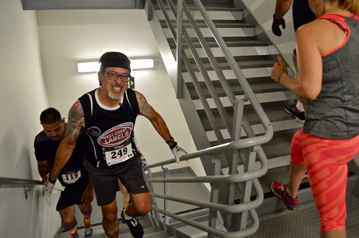
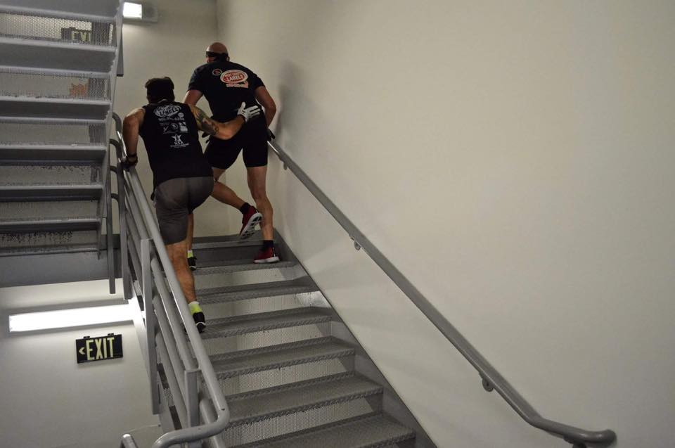
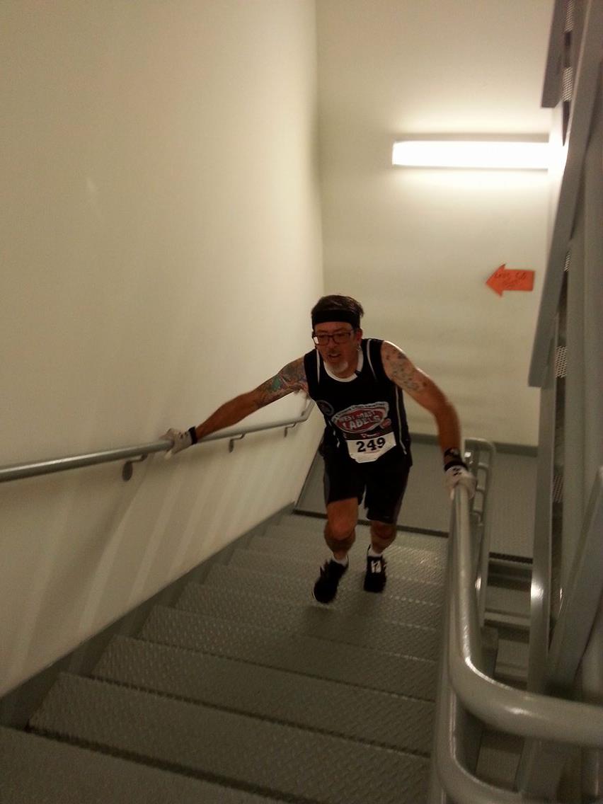
Today was the 2016 edition of the San Diego Towerthon. This is perhaps the single hardest stair-climbing race I’ve ever done, and also probably my favorite. It’s 422 steps, 239 feet, 72.9 meters from the lobby to the 20th floor. And we climb it over and over and over and over for two hours. This is my fifth time doing this event.

Last year, I only managed to do 19 climbs. The year before, I did 20. The two years before that were in a different building, so they aren’t easily compared. But the 2012 event was the origin of the Vertical Mile as a thing. In this building, 22 climbs is a vertical mile, but I’m not in good enough shape for that right now, although I did manage to do a two-hour vertical mile in practice at the Aon building in 2013.

This time, I started off at my regular ‘easy’ pace. I was aiming to climb the building in a bit over four minutes each time. And I managed to stick to that pace for quite a long time. There were some problems with the elevator shuttle back to the lobby at first. For a time, there was only one elevator running, and we ended up having to wait for several minutes at a time at the top. But after about a half-hour or so, they got the elevators working, and also the herd thinned out a bit.

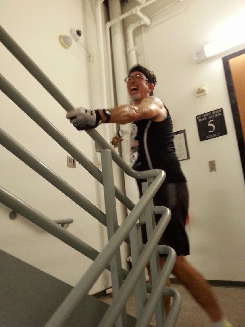
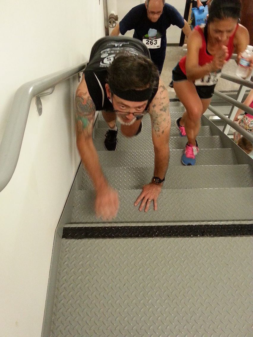
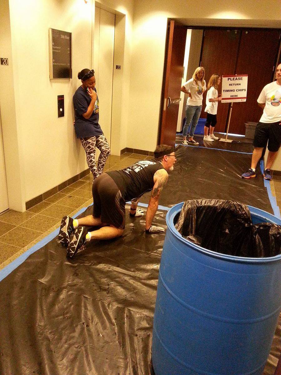
I had some water and Gatorade on the table in the lobby, and I stopped to tank up about every 15 minutes. At the one-hour mark, I stopped long enough to change to a dry headband. It wasn’t until about 90 minutes in that I really started to slow down. I kept a watch on the time, and I made it in to the stairs for my final climb at about 1:57 on the clock. So I knew that the last climb would count for my total, and that it really didn’t matter how long the last one took. Still, I managed to eke out a little burst of speed for the last three floors, just because I knew that I could stop when I got to 20.

Sadly, I didn’t get a lot of pictures this time. There were a few that other people took near the start, and Jeff showed up about halfway through. He wasn’t racing, owing to having been sick. But he was able to get some pictures for me on the last few climbs.

In the end, I managed 19 climbs, which was the same as last year. I think I’m slightly stronger this year, though. If we hadn’t lost those minutes waiting for the elevators at the start, I think I could have easily done 20 climbs this time. Still, I can’t complain. After all, my 19 is the same as the 19 George did, and he’s generally in better condition than I am these days. So all around, it was a good time.

Full results are at https://gemininext.com/results/?event_id=5066


6/12/2016

Little Orphan Oil Well

Filed under: — stan @ 5:25 pm

This past week, I saw an article about how two houses in Echo Park were found to have abandoned oil wells leaking natural gas and hydrogen sulfide in their front yards. Since we’ve gone on other rides to see oil-related sights in that area, I thought this might make for an interesting bit of sightseeing.

We started off with the usual 14 miles downhill into downtown Los Angeles. The only thing different this time was that I got flat along the way. And when I was checking the tire to find what had caused the flat, the little flake of glass embedded in it sliced my finger open. So I ended up bleeding all over everything while I fixed the tire. But I finally got it fixed, and we were back on the road.

In downtown, we paused for a moment to look up at the U.S. Bank building and see the glass slide they have installed from the 70th to the 69th floor. This is supposed to be opening in two weeks.

We rode down through downtown to check in on the Allenco Energy drilling island near USC. We’d been to see this a few times before, and it was in the news again this week. Apparently, the city has forced it to shut down until such time as they can enclose it in a fake building to control the smelly gases that leak from the site. It was quiet there, and we didn’t smell anything, so I guess it’s working…

Heading back into downtown, we passed the old apartment building on Olive St that had the oil oozing up in the basement back in 2006. Then we took 7th St out of downtown, and then turned north into Echo Park. We rode through one block where they were filming something, but we didn’t pause long enough to get any idea what. Then we arrived at Firmin St, where the orphaned oil wells are. One was pretty obvious, since it was inside a little chain-link fence enclosure in front of one house. The other one was across the street. The well itself wasn’t that obvious, but there was a posted notice from the state about how they had ordered that the well there had to be plugged and sealed off.

Continuing on, we went to our snack stop at Chango Coffee in Echo Park. Then we headed back past Dodger Stadium. This time, I’d remembered to check to be sure that there was not going to be game today, so the ride through the park there was pleasant. Then we headed back to Pasadena by way of the Arroyo Seco bike path.

39 miles.

Route map and elevation profile

6/5/2016

The Googie Bowling Alley Sign

Filed under: — stan @ 5:06 pm

We recently went to the Museum of Neon Art at their new location in Glendale to see the Sign Geeks exhibition of photographs of neon signs. There, they had one piece about the old Premiere Lanes sign in Santa Fe Springs. This is a great example of 1950s-style Googie design, and they had been working to have the sign preserved in some way after the bowling alley was torn down in 2010. I recently read that the city had approved development of the land, and that the sign would be coming down to be taken to the Valley Relics Museum in Chatsworth. So I figured that this might be our last chance to see it before it’s gone. We’ve done other rides to see famous examples of Googie architecture, so that was today’s ride.

The route was very similar to the route we took to downtown Whittier to see the antique street lights with the swastikas on them. Since the side trip to Santa Fe Springs would add several miles, I modified the route to cut off some distance at the beginning. So we started out just heading south, all the way to Whittier Narrows. We picked up the San Gabriel River bike trail, making the short side trip to go see Dork Street in Pico Rivera. then we rode the Whittier Greenway trail all the way to Greenleaf Ave. There was a nice segment of the trail where we rode over an old railroad bridge that took us diagonally above and across the very large Five Points intersection. Then we headed south to go see the sign.

Santa Fe Springs is apparently an industrial town. It looked a lot like Vernon did when we went to see the Farmer John packing plant a few weeks ago. We made it all the way to Telegraph Rd. where we saw the sign, standing tall over the vacant lot where the bowling alley used to be. We looked at it for a bit, and took some pictures. Then we headed back up into downtown Whittier and our snack stop at Mimo’s Cafe.

Coming back, we rode up the San Gabriel River and Rio Hondo bike paths, and then home through Arcadia. It was a pleasant ride to see a little bit of local history.

47 miles.

Route map and elevation profile

Powered by WordPress