Stan’s Obligatory Blog

2/7/2016

An Empty Freeway in Los Angeles is a Surreal Sight

Filed under: — stan @ 2:30 pm

Back in November, we took a ride downtown to see the 6th St bridge close-up. At the time, it had been announced that it was going to be torn down and rebuilt, but the work had not started yet. But this weekend was when the actual work got underway. The plan was to demolish the section of the bridge where it passed over the 101 freeway, just east of downtown Los Angeles. As with the famous “Carmageddon” on the 405 freeway a few years ago, this was going to require closing a section of the 101 freeway for about a day and a half. The closure was supposed to start on Friday night, and run until afternoon on Sunday. So of course, I figured the Sunday morning Foothill Cycle bike club ride should go and see it. A closed and empty freeway is extremely rare in Los Angeles. In 30 years living here, I’d never seen one before.

I’ve only been on a freeway on my bike two times. Once was when I was about 12, and there was about a two-mile stretch of the then-future Mt Nittany Expressway that was built but not opened yet. My friends and I rode our bikes there just for the novelty of riding on it. The other time I was in 1977, when I was a bike racer. One day when I was out riding, I caught a flat-bed truck carrying a bulldozer on an uphill stretch. Somehow, that truck made the perfect draft*, and I was able to draft off it for a good 10 miles, doing 40-45mph the whole way. I knew that the road we were on turned into a freeway up ahead, and I wanted to see if I could keep up with it when it hit full freeway speed. When it got going, I was able to keep up, spinning as fast as I could in my top gear. We didn’t have bike computers then, so I don’t know how fast I was actually going, but it was fast. Fast enough that, even though I was 17, I somehow realized that this was probably Not a Good Idea. I figured I’d made my point and I should probably get off the freeway at the first exit. Still, that was an experience.

Our route took us straight south to Rosemead, and then west through Monterey Park to East L.A. and Boyle Heights. We got to where 1st St crossed under the 101 freeway. There was an on-ramp to the northbound 101 which did not say it was closed. Cars were getting on the northbound freeway there, but it was pretty obvious that there was none of the usual freeway sound coming over the sound wall. So we headed south a few blocks to 4th St, which crosses the 101 on an overpass. From there, it was easy to see the completely empty freeway. There was an off-ramp from the freeway up to 4th St, so I rode down it to see it close-up and ride a quick circle on the empty freeway. Wow, that felt weird.

Continuing on, we took the 4th St bridge across the L.A. River to downtown. Then we rode the bike lanes down Spring St and 7th St before turning north and heading up to Echo Park. We stopped for snacks at Chango Coffee. Our route home went up the Arroyo Seco bike path back to South Pasadena, and then home from there.

40 miles.

* Drafting a truck on a bike was tested by the Mythbusters, and they deemed it “Plausible”, but I can personally attest that it is “Confirmed”.

Route map and elevation profile

2/5/2016

My Pet Project Turns Ten

Filed under: — stan @ 11:00 pm

The USGS Earthquake Notification Service, also known as My Pet Project, went online to the public on January 31, 2006. It all started back in about 2000, when I was talking to someone from Caltrans, and he was asking if we could set up something where they could put in lat/lon coordinates of key freeway bridges and interchanges, and then be notified any time there was an earthquake within some distance of any of them. At the time, we couldn’t do anything like that. But then, fate intervened.

We have occasional cookouts at the office, and in 2003, I thought it would be nice if I could set up a web form for people to fill out online so that I knew who was coming and what food they wanted. I thought this would be sort of like a gift registry, so I went on Sourceforge and found a little gift registry program that someone wrote. I downloaded it, and I hacked it to make an online signup for our office cookouts. In the process of doing this, I learned a bit of MySQL. And then, when I was riding my bike in one morning, I realized that a database like MySQL could do something like what the guy from Caltrans had asked for. So I whipped up a simple database with some rudimentary geographic information, I plugged in the worldwide earthquake feed, and it started sending me earthquakes from all over the world.

I recruited a few ‘guinea pigs’ around the office to set up accounts in it for testing. They suggested other things they would like it to do. At first, it could only define geographic regions as lat/lon points defining a box. People asked for circles, and then arbitrary polygons. Drawing a polygon on the map and figuring out if a given earthquake fell inside it kept me thinking for a while, but I worked out a reasonable way to do it. And while all this was happening, my little system was being shown around to everyone, until the National Earthquake Information Center saw it and decided that it should be an official product of the Earthquake Hazards Program.

We had a few old-style mailing lists that were open to the public at that time. One for worldwide quakes M5.5 and over, and two for California quakes. One for M3 and higher, and one for M4. Those mailing lists formed the initial subscriber base. I wrote some scripts to port the mailing lists over, creating an account for each person with notification rules that would give them the same earthquakes they had been getting before. All told, this made for about 100,000 initial subscribers.

Now it’s been ten years, and it now has about 400,000 subscribers. Over ten years, that’s an average of about 80 new subscribers every day. Most days get about 30-35 new subscribers, but this goes way up after big earthquakes. The largest jump was about 75,000 new subscribers in the two weeks after the 2011 M9 Tohoku Earthquake in Japan.

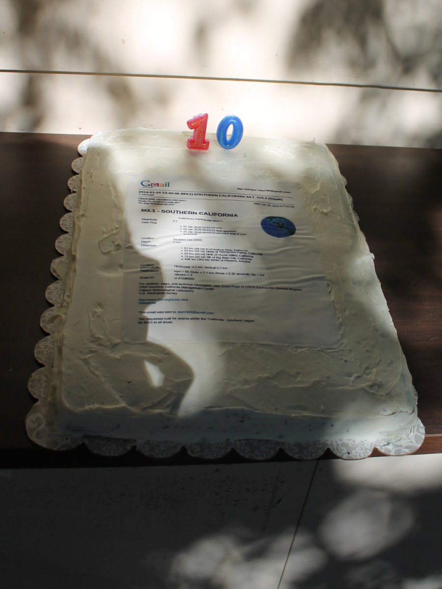
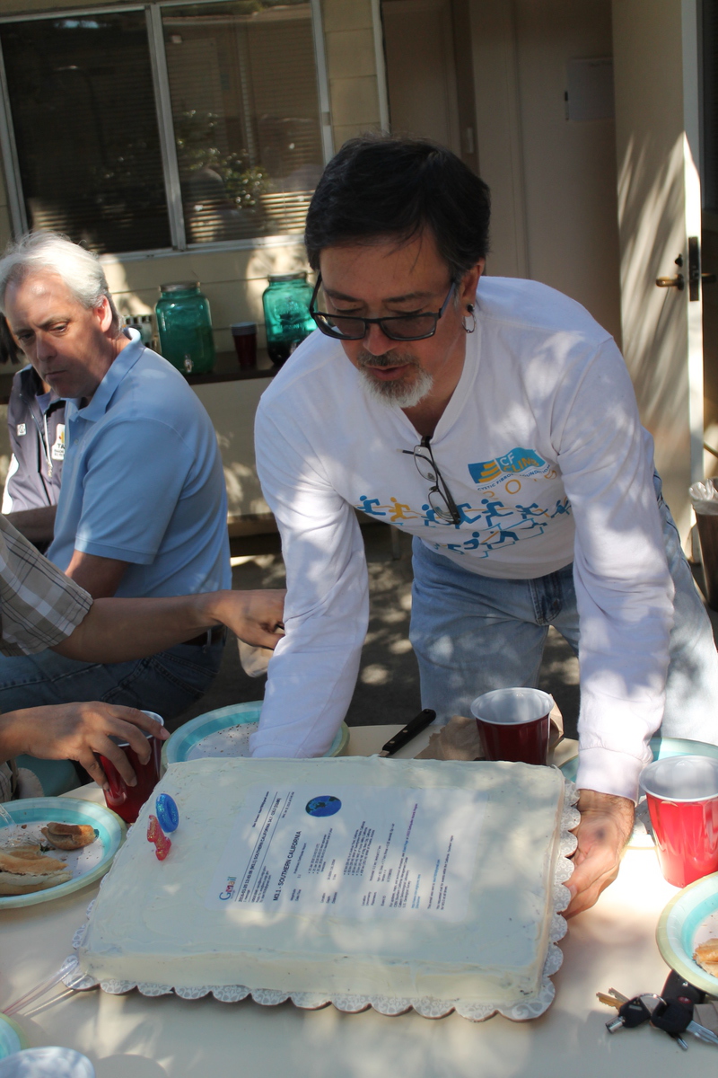
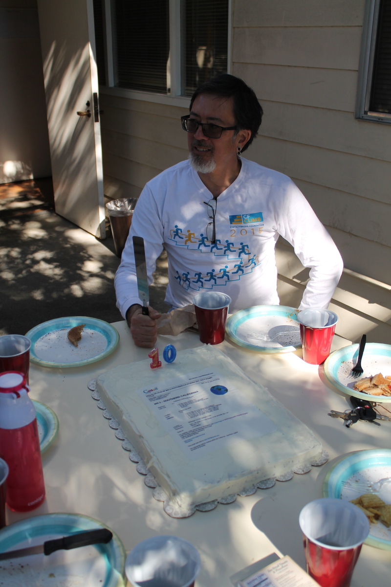
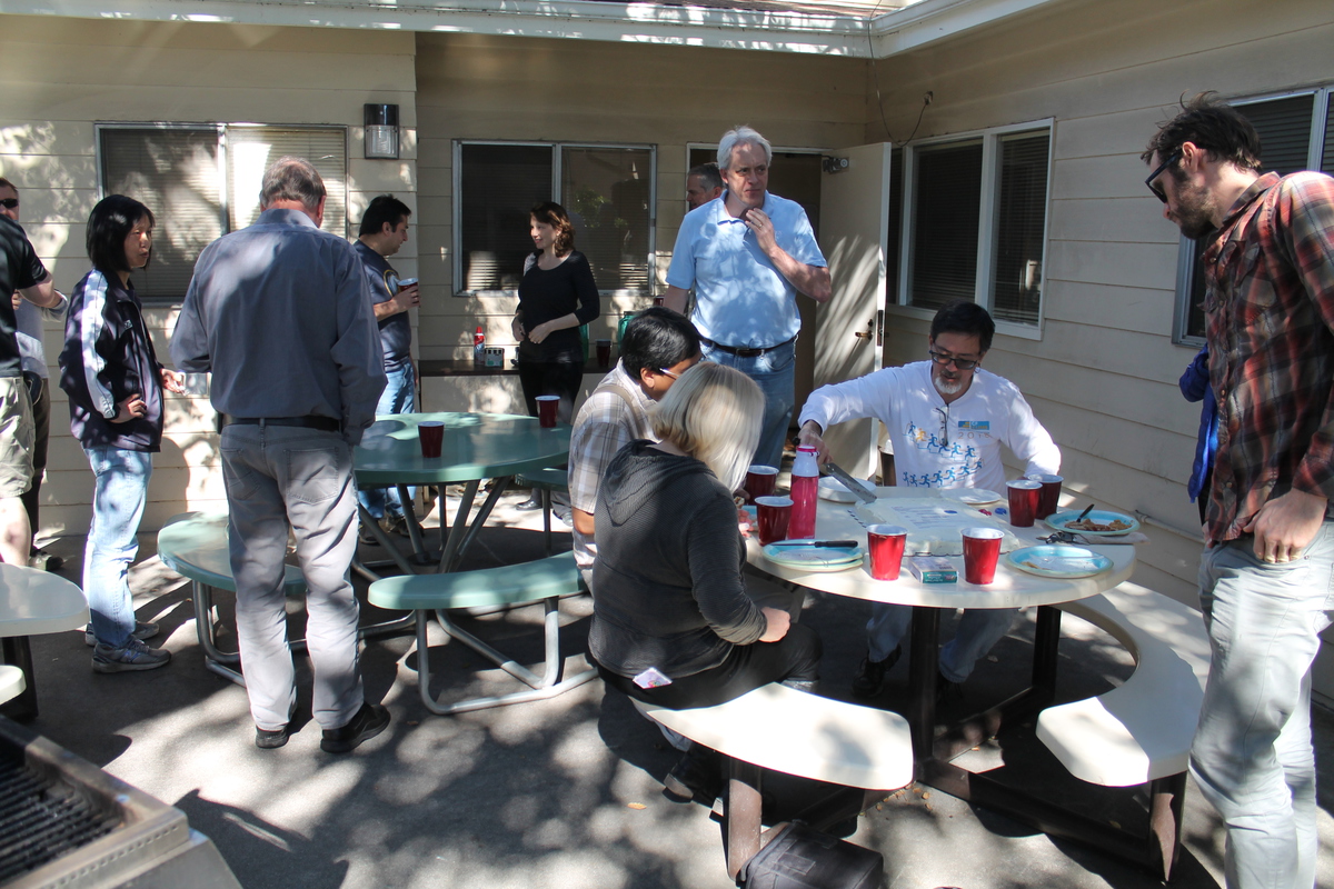
Because this all started from wanting to have an online signup form for the office cookouts, I thought we should have a cookout for the occasion. I made a cake, and we all gathered out on the patio behind the office. It was a nice time. And it’s still amazing to me that this thing I wrote that started out as a little Pet Project has turned into a thing. And that’s it’s used by 400,000 people. And in the end, I guess that’s the greatest satisfaction.

1/21/2016

First stairs of 2016

Filed under: — stan @ 9:09 pm

So here we go again. This was my first practice session at the Aon building in downtown Los Angeles. 1,126 steps, 691 feet, 210 meters from the 4th floor to the 55th. My only goal for the evening was to make it up the building five times for a Vertical Kilometer. The first two times I was able to maintain my target pace pretty well. After the second climb, I took a minute to look at the nice sunset view from the 55th floor. Then I headed back down for the third climb. That was quite a bit harder, and I went a bit slower. But when I got to the top, I found Nathan up there. So we did two more climbs together, just taking it easy and talking all the way up. But still, climbing this big staircase is just fundamentally a different experience from doing the little 10-story climb at Millikan Library. Even doing that 12 times in a session is not as hard as doing 51 floors all at once. But still, I made my vertical 1-k.

1/17/2016

Visting the point of impact

Filed under: — stan @ 1:40 pm

I’ve recently been binge-watching the airplane disaster series “Mayday“. One of the episodes told the story of Hughes Airwest Flight 706 which crashed in the mountains just north of Duarte in 1971, after colliding with a Marine Corps fighter jet. In the process of reading more about that incident, I fell down the Wikipedia Rabbit Hole, and discovered that there had been another crash involving a mid-air collision near here, and it occurred just a few blocks off of one of our regular bike ride routes. Since it happened 41 years ago, I knew that there would be no trace of it now, but I still thought it might be interesting to visit the site.

The accident in question was Golden West Airlines Flight 261, which was a short hop from Ontario to LAX. They were heading west toward LAX, directly into the setting sun, when they were hit from the side by the second airplane, and the debris fell in Whittier.

We took our usual route down the Rio Hondo bike path to Whittier Narrows. Then we tried a little experiment, taking Durfee Rd to Peck, and then Rooks Rd down the west side of the 605 freeway. Then we resumed our regular route into Whittier. A second experiment was to take the Whittier Greenway Trail, which is an old railroad right-of-way that has been converted into a bike path and walking trail. That turned out to be very pleasant, and I think we will have to go back and see some more of it another day.

A short side trip brought us to Katherine Edwards Middle School, where the fuselage of Flight 261 fell on the playing field behind the school. Other parts fell on the neighborhood surrounding the school.

Leaving the crash site, we headed back up the San Gabriel River bike path to Whittier Narrows. Then we took a short side trip to Legg Lake to see a bit of a cyclocross race that was being held there. We also ran across a small military museum just on the north side of the 60 freeway. Then we continued north on Tyler Ave, heading for Arcadia.

We stopped briefly at the El Monte Metrolink station to see the station artwork, which recalled the days when El Monte was known as the home of Gay’s Lion Farm. Continuing north, we got to Arcadia, and then headed home from there. It was very cold when we started out this morning, but it warmed up nicely, and in the end it was a very pleasant ride.

45 miles.

Route map and elevation profile

12/22/2015

Last stairs of 2015

Filed under: — stan @ 5:46 pm

About the middle of November, I was curious, and I added up how many times I’ve climbed the 10-story staircase at Millikan from the basement to the landing at the roof door. At the time, it was something like 1,240 times, so I decided to set a goal of making it to 1,500 climbs by the end of the year. When I go over there with Nick to climb, we generally do a set of 12 climbs each time. So I figured that doing 260 climbs over six weeks was possible. That’s not quite 22 sessions over 42 days. So the clock was ticking.

Today was the finish. And not a moment too soon, since the building is closed from Christmas day through the end of the year, so I had to finish by the 23rd. And I wanted to space out the sessions so I wouldn’t have to do a marathon session at the end. A few years ago, I went and climbed it 18 times on the last day it was open, and that got grim the last four or five times.

So here it is. 1,500 climbs up Millikan. That makes 63km vertical in this building alone. And with the 21,640 meters of climbs in other buildings, my total stair climbing for the year stands at almost 85km, which is just a bit over 52 vertical miles. That means I averaged a vertical mile of stairs every week this year.


12/13/2015

More Urban Archaeology

Filed under: — stan @ 2:28 pm

Two weeks ago, we rode into downtown Los Angeles to see the 6th Street bridge, and also to see some fossilized tracks from the former Pacific Electric Air Line. The same web site where I found out about those tracks also had a note about the old bridge over Ballona Creek in Culver City. Apparently, the bridge and old tracks are still there, and Metro just built the new Expo Line elevated tracks above it. So today’s ride was a trip out there to see the old bridge.

We started out heading into downtown L.A. bu our usual route. There was some sort of lowrider car show going on in front of City Hall. Continuing south, we picked up West Adams Blvd and took that out to just past Crenshaw. Then we went south a few blocks and got on the bike lane that parallels the new Metro Expo Line. That brought us to just past the La Cienega station, where the bike lane becomes a bike path, and crosses Ballona Creek right next to the old Air Line bridge. It’s kind of remarkable that the bridge is still there, and still in pretty good condition.

After looking at the bridge a bit, we continued west on the bike path, and then turned off on Helms Ave to go up to the old Helms Bakery complex, which has been turned into stores and restaurants. We went to a little cafe there called La Dijonnaise. The food was pretty good, and it was pleasant sitting out on the patio there.

The route home took us back into downtown by way of Venice Blvd, 9th St, and 7th St. Then we took the Arroyo Seco bike path from just east of downtown all the way to South Pasadena. It was a good way to come home, since the Arroyo bike path is essentially flat all the way.

47 miles.

Route map and elevation profile

11/29/2015

The 6th Street Bridge

Filed under: — stan @ 5:40 pm

Today’s bike club ride was a trip through downtown Los Angeles to see the soon-to-be-demolished 6th Street bridge, and also to see some remnants of the former Pacific Electric Air Line tracks.

We rode into downtown Los Angeles by our regular route down Huntington Drive. But just before Alameda St, we turned left and made our way south parallel to the river and railroad tracks. At 4th St, we took a side trip up onto the bridge there to get a view of the 6th St bridge from the north. Then we continued south a bit more, passing under the 6th St bridge. I never knew there was a ramp under the bridge leading to a tunnel under the railroad tracks and out to the river. So that’s how they got cars down the riverbed for all the movies that had car chases and races in the L.A. River.

From just south of 6th St, we got a good view of the arches on the bridge. Then we continued south on Santa Fe St to see the building that Robert’s great-grandfather built to house their family business in 1910. And the business is still there, 105 years later.

Turning west, we crossed over to Grand Ave going south. At about 35th St, there were some rails embedded in the sidewalk. They are remains of the old Pacific Electric Air Line to Santa Monica. Most of the Air Line right-of-way is now being occupied by the Metro Expo Line. But the part east of Flower St is not. We rode around to the DMV office at 37th St. There were some more rails embedded in the parking lot there. Then we headed north on Figueroa to continue our ride.

The rest of the ride was a loop through Hancock Park, and then home by way of Silverlake. And we got to see the Silverlake reservoir drained. Then we crossed the river and headed north. That was where I got a flat. But even with that, it was a pleasant ride.

49 miles.

Route map and elevation profile

11/22/2015

Atlas Still Survives

Filed under: — stan @ 2:07 pm

A few years ago, we took a ride to see Atlas Survival Shelters in Montebello. There had been an article about them in the L.A. Times, and we wanted to see the model shelter they had parked out in front of the building. With all the new angst about terrorism in the wake of what happened last week in Paris, I was curious to see how the survival shelter business was doing, so we rode back there to see today.

On the way through San Gabriel, we came across a road closure at the railroad tracks. We’d seen this before, and I remembered that there was a makeshift sidewalk to get across, so we took that, and we got a good look at the trench they are building to put the railroad tracks below grade.

After a short trip down the Rio Hondo bike path, we off in Montebello. We took a wrong turn there, and ended up having to carry our bikes down a short flight of stairs to get back on track. I’d forgotten about that, but back when I was in college, I learned to ride my bike down steps like that. And that made for my favorite college yearbook photo ever.

When we got there, we saw that they don’t have a model shelter on display in front of the factory any more. They still have one banner on the side of the building advertising the survival shelter business. But everything else was just about their regular ironworking business. And while we were there, Michael sat down to fix his leaking tire.

The ride back was pleasant enough. It was a very nice day, although we had a headwind all the way up the bike path, and all the way to Merengue in Monrovia. We had some snacks and then headed for home.

39 miles.

Route map and elevation profile

11/14/2015

Working Wildlife

Filed under: — stan @ 9:53 pm

Today was a tour of Working Wildlife, which is a ranch in Frazier Park where they train animals for movies and TV. This was yet another Atlas Obscura adventure. As it turned out, it was the same day as the Cystic Fibrosis Foundation’s stair climb, so I had to leave right after climbing the building in order to have the requisite 90 minutes to make it all the way out there. But I made it just in time, and it was a fun time talking to the animals.

At the beginning, we got a little history of the ranch, and got to meet a few of the smaller animals. Our host and guide was Jeff, who is one of the trainers, and the nephew of the owner. The lemur, porcupine, and the binturong got to just walk up and down the table and meet us directly. And after that, it was time to meet some larger animals. We saw a few foxes before heading over to the lions. We saw a couple of mountain lions, and then some African lions. They all seemed to have a good relationship with Jeff, since they all came over to him and wanted to be petted and scratched just like very large cats. I seem to recall he said that the pumas are the largest cats that purr.

The last stop was to see the bears. They also came over to be petted, although, like with the lions, the petting did not involve us, since the bears and lions don’t know us. The only other part of the operation we didn’t see was the wolves. Apparently, they trained the wolves that were used in “True Blood” and other TV shows, but the trainers were working with the animals and didn’t want them to be distracted by visitors. Still, it was all very interesting to see.

Well, I’m still slightly faster than the Average Bear…

Filed under: — stan @ 4:37 pm

Today was the last race of the year. 54 stories from the sidewalk on 6th St up to the rooftop helipad on top of the Wilshire Figureroa building in downtown Los Angeles. That’s 1,245 steps and 706 vertical feet. This is the building that I climbed 101 times in 2013.

I’m not seriously trying to compete at these things any more, but I still wanted to do a semi-respectable time on it. And I figured that to be anything under 11 minutes, since that would represent averaging 5 floors per minute. It’s also an easy pace to keep up with. The staircase in this building is an average of 23 steps per floor, and from 1 up to 6 is exactly 115 steps, even though the first few floors are weird. And then it’s just 23 steps per floor the whole way up. So I planned on checking my watch every five floors to be sure I was maintaining my pace.

The first 10 floors or so were hard, but by then I was warmed up, and it got a little easier. I just counted off the floors in blocks of five, all the way up to 49. From 49 to the roof the stairs get weird again, so I didn’t have any landmarks to measure my pace by. But when I turned the last corner and saw light coming in the door from the roof, I looked at my watch. It said something like 10:47 or so, and I realized I had only ten seconds to do the last 27 steps up to the roof to make it in under my goal time. So I had to run the last three flights, and I came out on top at 10:57. I hadn’t realized it, but Norman Schwartz was there taking pictures, and he got what is probably my most dramatic finsh-line picture ever. And only four people my age or older went faster, so I really can’t complain.

At the top, I rested for a few minutes, took a few pictures, and then I went back down and left. I had a ticket for an Atlas Obscura tour of Working Wildlife in Frazier Park. I knew I had to get going to make it there by 11:00, so I couldn’t stay around and socialize much. Still, I was reasonably pleased with this climb.

Full results are here.

Powered by WordPress